Monsoon Summary (June 15 – Sep 18)
We are nearing the end of the 2014 season, and while it is difficult to characterize the highly variable day-to-day storms of any monsoon as “normal,” we have had a fairly typical if not above-average monsoon season in terms of precipitation. Regional assessment is complicated by the effects of a few extreme events that amplified precipitation amounts in parts of Arizona and New Mexico and caused an entire month’s or year’s worth of precipitation to fall in a single storm.
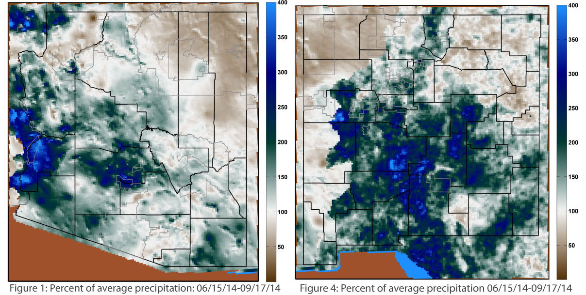
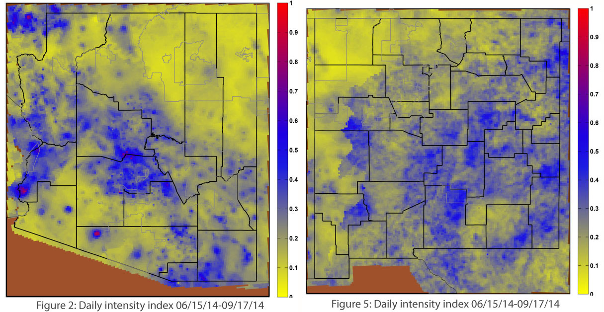
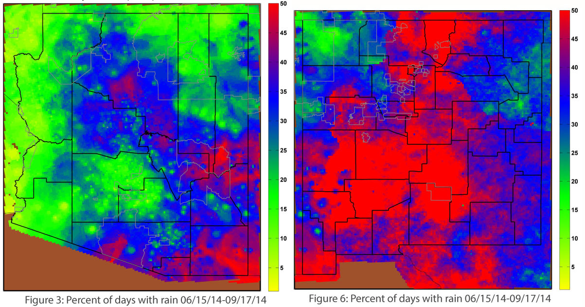
Southeast, southern, west-central, and the high-elevation areas of central Arizona have all seen impressive monsoon totals, with precipitation ranging from 200 to 400 percent of average. Most of Arizona, in fact, has seen above-average seasonal monsoon precipitation (100-200 percent of average) with the exception of the Four Corners region, which is struggling with below-average precipitation and long-term drought (Figure 1). The intensity of these storms, measured as the ratio of total precipitation over the time period to the number of days observing rain, in inches per day (Figure 2), reveals that some areas—western Arizona in particular—received a significant portion of their monsoon precipitation in a few extreme events, and in some cases a single storm. These intense storms offer little in the way of long-term drought relief but pose major threats in terms of their destructive potential, especially in urban/metropolitan areas. Figure 3 (the percentage of days observing 0.01 inch or more) illustrates which areas received more consistent and steady rain.
New Mexico has seen a strong monsoon as well, with most of the state receiving well-above-average precipitation, and large portions of central and southern New Mexico receiving 200 percent or greater of average precipitation. As with Arizona, the Four Corners region is below average, as is the northeastern corner of the state (Figure 4). Maps of the intensity and frequency of monsoon precipitation in New Mexico (Figures 5 and 6, respectively) show larger areas of more frequent, less intense storms. This precipitation should help mitigate short-term drought conditions, but long-term deficits remain.


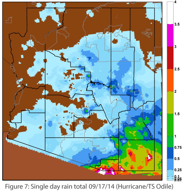
Tropical storms have been active in the Pacific, and while early-season storms veered into the Pacific Ocean, recent storms (Marie, Norbert, and Odile) have followed the later-season pattern of re-curve into the Pacific coast, boosting precipitation in the Southwest (albeit in a highly variable way). Norbert caused considerable flooding in Phoenix and to a lesser extent in Tucson, and on September 17 Odile caused most of southern Arizona and New Mexico to brace for the worst, with projections of 3-6 inches of rain for those in the direct path. The storm eventually swung south, and most of the impacts were felt in northern Mexico and far-southern Arizona (Figure 7).

This post was originally published as part of the September 2014 Southwest Climate Outlook

