El Niño Watch - July 18, 2014
Originally published in the Southwest Climate Outlook, released the 3rd Thursday of every month. Sign up for email newsletter version.

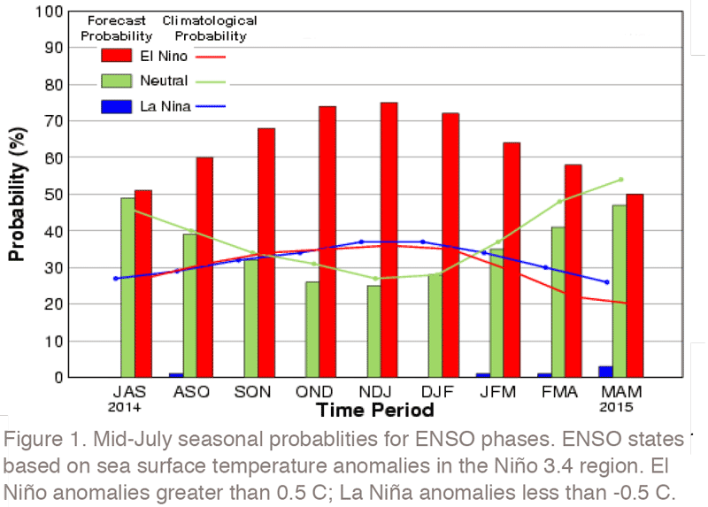
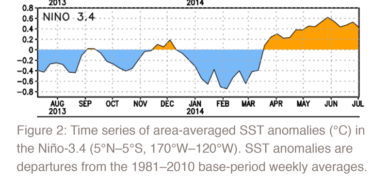
The El Niño event that has been anticipated for the past several months continues to suffer from stage fright; it has yet to fully materialize across the equatorial Pacific Ocean. Nonetheless, forecasts remain bullish that an El Niño will form in coming months, and consequently the El Niño Watch is still in place. Probabilities that an El Niño will fully materialize this fall and winter reach slightly more than 70 percent, according to the mid-July ENSO forecast issued by the NOAA-Climate Prediction Center (CPC) and the International Research Institute for Climate and Society (IRI; Figure 1). These high probabilities reflect above-average sea surface temperatures (SSTS) in the far eastern Pacific and weak westerly winds in the central Pacific. Belief that this event will evolve into a strong El Niño, however, has lost muster because SSTs have hovered slightly above average and not steadily climbed (Figure 2). In addition, the atmosphere has failed to cooperate in a manner consistent with above-average SSTs. For an El Niño to gain strength, the warming SSTs in the central Pacific need to be accompanied by a subsequent weakening of the easterly trade winds which, in turn, reinforce warm SSTs. The easterly winds have yet to slacken as much as expected.

Nonetheless, the CPC forecast suggests that both the ocean and atmosphere are transitioning to and ultimately will become an El Niño. Feeding this expectation is the observation that convection in the central Pacific has become more organized in recent weeks. This indicates a growing atmospheric connection with the SSTs that could eventually lead to a weakening of the trade winds. Moreover, many of the dynamical forecast models (those that included both ocean and atmosphere dynamics) suggest a rapid warming in the central Pacific during the August–October period, with the El Niño event peaking in mid-winter of 2014 and 2015. Although the ultimate strength and duration remains uncertain, a weak to moderate event appears the most likely outcome, and the CPC notes the possibility for a strong event has diminished greatly in the past several months.

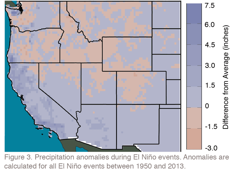
El Niño events tend to bring wetter conditions to the Southwest during the winter (Figure 3), with moderate and strong events delivering higher chances for above-average precipitation. However, if the El Niño event is weak, the precipitation outlook for the upcoming fall and winter becomes more uncertain. The strength and duration of the event should become clearer over the next two months as ocean and atmosphere signals lock in to each other.

