CLIMAS Southwest Climate Outlook - Apr 2017 Climate Summary
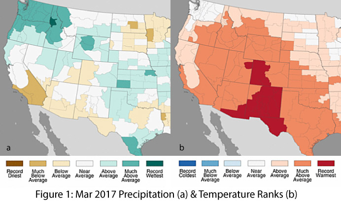
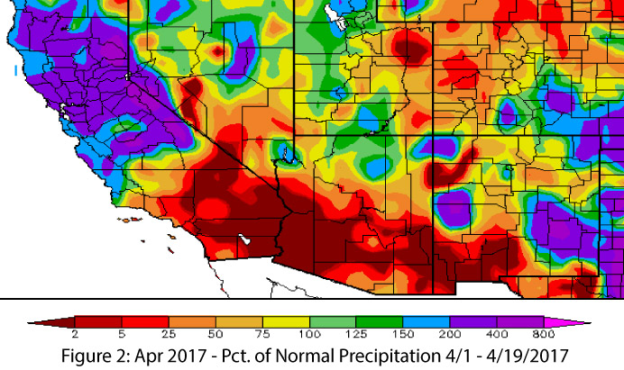
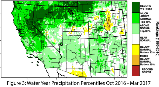
Precipitation & Temperature: March precipitation totals were average to below average in most of the Southwest except for the northeastern corner of New Mexico (Fig. 1a). March temperatures were much-above average across the entire Southwest, with record warm temperatures in the southeast corner of Arizona and most of New Mexico (Fig. 1b). April precipitation to date has been below average for much of southern Arizona and New Mexico (Fig. 2), while April temperatures have been between 0 and 6 degrees above normal for most of the region. Water year precipitation has been normal to above normal for most of Arizona and New Mexico, aside from a dry region along much of the Arizona-Mexico border (Fig. 3).
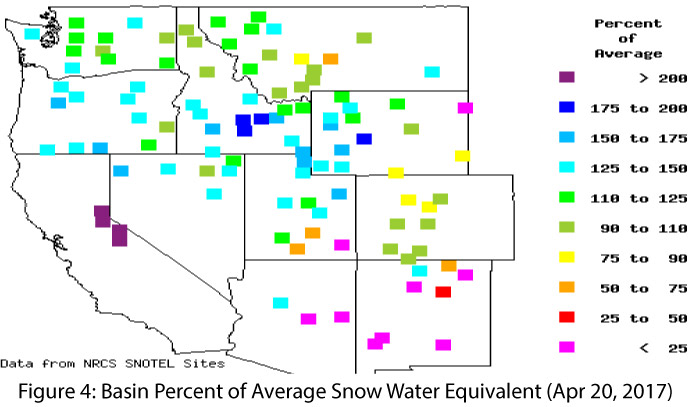
Snowpack & Water Supply: Warm temperatures across the West (particularly in the Upper Colorado River Basin) have begun to put a dent in the snowpack and snow water equivalent (SWE) values this month, especially in warmer low-elevation areas. Most of the stations in Arizona and New Mexico have dipped to below 50 percent of normal SWE, a decline that is also reflected in the Upper Colorado River Basin region of Utah and Colorado (Fig. 4). Snowpack and SWE remain markedly above average in other locations in the West, particularly in much of the Great Basin and the Sierras in CA. The persistent warm temperatures of early 2017 combined with the ample snowpack are resulting in similarly remarkable streamflow forecasts, as well as improvements in reservoir storage values (see reservoir levels).
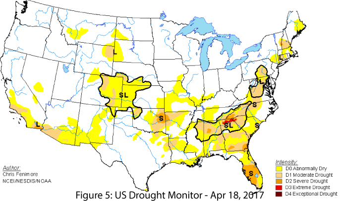
Drought: While much of the West has seen improvements in drought conditions (notably, California declared an end to its drought), southern Arizona and New Mexico have experienced an increase in drought designation, especially near the borderlands, owing to near-record- to record-warm temperatures and very little precipitation in the last few months (Fig. 5). Thus the wetter-than-normal conditions that helped reduce drought conditions across much of the West (see Fig. 3), provided only short-lived recovery in southern Arizona and New Mexico.
Environmental Health & Safety: The impressive wildflower bloom has continued, fueled by a combination of fall and early-winter precipitation and sustained warm temperatures over the last few months. These conditions have also resulted in a particularly bad year for allergies, with sustained growing periods leading to high pollen levels across the region. The warm and dry weather continues to produce dry and dusty conditions, again resulting in numerous closures of interstate highways when dust conditions are severe. The temperature and precipitation patterns of the past six months have also contributed to elevated levels of fine fuels, so with temperatures on the rise and precipitation on the wane, fire managers will continue to keep watch very carefully, especially on days when high winds and low dew-point temperatures create conditions favorable for fire ignition and spread.
El Niño Southern Oscillation: Current forecasts suggest ENSO-neutral conditions continuing through the spring and early summer, with increasing chance of an El Niño event during the second half of 2017 (see ENSO Tracker).
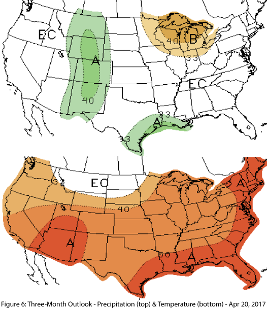
Precipitation & Temperature Forecast: The April 20 NOAA Climate Prediction Center’s outlook for April calls for equal chances of above- or below-average precipitation, and increased chances of above-average temperatures across the region. The three-month outlook for May through July calls for equal chances of above- or below-average precipitation in most of Arizona and increased chance of above-average precipitation in New Mexico and the remainder of Arizona (Fig. 6, top), along with increased chances of above-average temperatures across the region (Fig. 6, bottom).


